UPDATE 4 May 2023, 11.45am
I made oral submissions during the Planning Board meetings, raising the points detailed in this article below. The board then deferred the meeting with the understanding that the applicant would lower the height of the building and make the facade more compatible with surrounding townhouses.
Last November I imagined that I had something that would derail the application for proposed four-storey block of flats in the scheduled setting of Ta Kola, Malta’s most popular windmill. I published the findings and, together with four environmental NGOs, presented them in the Planning Board meeting. The main finding: the Planning Authority had refused an application a year before for a building of same height and lesser bulk double the distance away from the windmill. The refusal had been based on an assessment of the Superintendence of Cultural Heritage, which had said that the proposed building would impinge on views of the windmill. Yet the same Superintendence gave its blessing to the proposal in front of the Planning Board last November.
The board sent back the case to the Planning Directorate for an assessment into the difference between the two cases.
And now I have discovered something else: the enormous capacity for travesty in our so-called planning system.
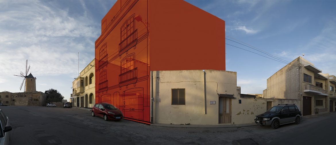
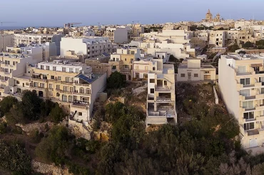
It would be hilarious if it were not so serious: the block of flats would not only mar the windmill’s protected setting, it would set a precedent for the wider setting of Ggantija Temples. At present the entire neighbourhood, which falls within the temples' buffer zone, consists of two-storey baroque townhouses building in the 1970s and 1980s. The neighbourhood holds architectural and cultural value, and forms part of the attractive setting of the windmill as well as Ggantija. And approving the proposed development would herald a new wave of redevelopments in one of the few areas in the country that still survives as an enclave of two-storey townhouses. There are currently five applications for blocks of flats.

So what did the Planning Directorate say after the board sent the case back for reassessment?
In its bizarre reasoning, the Planning Directorate held that the other building – the one refused permit in 2021– would have made an impact on visual integrity of the windmill because of a third floor that would not be recessed from the façade. Well, the building that it is recommending for approval also has a third floor and it is also not recessed, only its fourth floor is recessed.
It also said that the road on which the proposal is situated, called Triq Il-Mithna, is not the “main road leading to the scheduled windmill.” I cannot see the logic, within planning policies or otherwise, of this point – it could even be argued that Triq Il-Mihna is the more important road as it is road most tourists take.
More grotesque still is the characterization of the location, presumably an attempt to justify recommending the four-storey block of flats. The directorate said that the proposed building is situated “within an open piazza having buildings of different height, design, rhythm and proportions.” Yet all the buildings around the perimeter of the clearing (or “piazza”, to use the directorate’s grandiose term) are two storeys high, some of them with washrooms on the roof. The only deviation from the two-storey pattern is the vacant plot where the proposed block of flats is sited.
Perhaps the directorate was referring to the buildings around the corner, down a street that branches away, where one or two buildings are comparable in height with the proposed development. But these are only visible as receding away from some the furthest parts of the “piazza”, and they are not part of the all-important Area of Influence. This is a planning term that defines which adjacent buildings have to be taken into account in a scenario such as this one – a proposal that falls within the scheduled setting of a top-grade heritage building. According to this guideline, it is the buildings on either side of the proposed development along the same street that have to be taken into account when deliberating on permissible height. And in this case, those buildings are two-storey townhouses.

The architect in his submission did indicate the height in number of courses of those buildings round the corner, even though these do not fall in the Area of Influence. This is a deviation from the guidelines on submissions in the policy document known as DC15 – as well as Planning Circular 4/16 – which specify which adjacent buildings have to have their height marked or indicated in street elevation submissions.

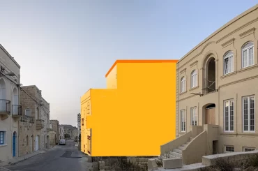
The photomontages presented by the architect are also selective and, in the more crucial viewpoint along Triq Il-Mithna, the photomontage does not show the building as it would loom over the one-storey house that is adjacent to the site of the proposed development.
There are no photomontages of long-distance views – not even a photomontage from the Xaghra Circle, a Neolithic burial shrine and a major archeological site. And the Planning Authority took no consideration of impact of proposal on long-distance views. Such consideration of long-distance views in proposals that fall within the scheduled setting of top-level heritage buildings is one of the points made in policy.


There are a scatter of other buildings that are of similar heights on the skyline. But this does not justify further disfigurement, neither in logic nor in policy. The key policy document in this regard – on development near scheduled buildings, Circular 3/20 – says that “the effects of recent commitments should be mitigated rather further marred, towards the improvement of the overall context of the scheduled building.”
I could go on and on. The stark reality is that confidence in the Planning Authority has never been so low. And confidence in the Superintendence of Cultural Heritage has also plummeted in recent years.
On this case, the Superintendence' logic has been incomprehensible in terms of policy. After writing that the “photomontages do not indicate that the proposed development will have a significant impact on the perception of the scheduled windmill” , it then added that this position is “without prejudice to adjacent sites closer to the scheduled windmill which may be subject to appropriate mitigation measures.” Well, the building is already in the protected scheduled setting, just 30 metres from the windmill, how much closer would we need to get before we get to the “appropriate mitigation measures”?
But there is hope, recent court judgements offer hope. Several weeks ago the Court of Appeal revoked a permit in Santa Lucija that was in breach of policies that also apply for this proposal (Appeal No 75/2022, 15 March 2023) . And several months ago the Court of Appeal (Appeal No 17/2022, 7 December 2022) also revoked a permit for a building in Pieta twice because the permit did not conform to Area of Influence provisions.
I have a high degree of confidence that the people shall prevail, if not at the Planning Authority then in court. But we have to get engaged and remain engaged, and then ultimately get to funding court cases if this goes through.
This is the point of this special reportage, Ggantija Streetscapes, to reveal and rally. So I urge you to subscribe to the series by filling in the subscription form below. Subscription will enable you to receive news of significant happenings and coverage as we go along. Together we can protect Ggantija's buffer zone.
Donate to Ggantija Streetscapes
It takes much resources, time, and effort to do the research and digital renditions to produce the reportage of the Ggantija Streetscapes investigative reporting project published on this website. More work is involved in appearing in front of the Planning Board to make submissions. I largely rely on donations for my income to run this website. Sustain this effort by donating as little as €5.

